Not long after the exciting discoveries at Clunes and Buninyong, gold was discovered on Yuille’s Ballarat Station in August of 1851. John Dunlop and James Regan discovered gold at Poverty Point between the 20th and 24th of August, followed closely by Tom Brown’s discovery less than a mile away at Golden Point.
“Tradition has it that a man named Morrow, a carpenter at Geelong, was the only one who could give information as to where gold was likely to be found. His advice was very simple. He said ‘Wherever you find round gravel pebbles try for gold;’ and it was acting on that hint that the rapid succession of gold discoveries were made which had led the building up of Ballarat, and have had such an important effect upon the development of Victoria.” – The Ballarat Star, 28th August 1896.
Ballarat’s initial gold rush in 1851 focused on the rich surface alluvial gold deposits, where miners searched for gold in the gullies and surrounding shallow areas.
But it wasn’t long before skilled miners looked a little deeper, discovering the unfathomable wealth which lay waiting in the now famous deep leads below!
1852 onwards saw Ballarat leap into action! Miners excitedly discovered lead after lead, working in unimaginable conditions in hope of seizing the riches which lay deep beneath their feet.
This page provides a directory of historical gold maps for Ballarat, Victoria. All these maps are available to view online for free.
Ballarat historical gold maps
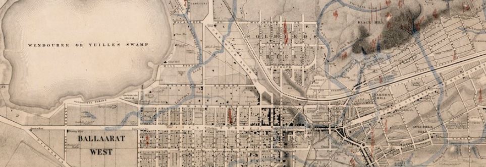
- 1859, mining district of Ballaarat. Shows reefs, leads, gullies, workings.
- 1861, Ballaarat gold field. Shows leads, reefs and outcrops.
- 1863, plan of leads and gold workings at Ballaarat. How the frontage system changed gold mining at Ballaarat, includes map and notes.
- 1868, gold fields Ballaarat, drawn on stone by E. Gilks, from information supplied by mining surveyors Cowan and Davidson. Shows leads (depth of leads from surface, height of surface above sea level), quartz reefs outcropping, granite, basalt, indurated clays and sandstone, palaeozoic.
- 1870, Niven’s Mining Map of Ballaarat. Shows leads, gullies and companies (including their claim areas and amount/depth/area of gold obtained).
- 1870, plan of Ballarat, Sebastopol and Buninyong gold field showing mining areas to be drained by a proposed adit along the valley of the Yarrowee River. Shows reefs, gullies, various geological features.
- Ballarat gold field, geological survey, 1874. Shows gold workings and leads, most recent drift, recent drift, volcanic, older gold drift, oldest gold drift, lower silurian, quartz reefs, proved auriferous reefs, points of volcanic eruption, shafts, sub basaltic reef washes. Includes detailed notes.
- Ballarat gold field, geological map, 1917. Shows recent alluvial, thin capping, post basaltic gravels, new volcanic, inter-basaltic clays, gravels and drift, sub-basaltic clays, gravels and drift, deep leads where exposed, reef wash where proved under newer deposits, high level pre-basaltic gravels, ordovician shales and fine grained sandstones. Also shows shafts, alluvial, dykes, anticlines and synclines.
Purchase high quality A1 print of the Ballarat Goldfield
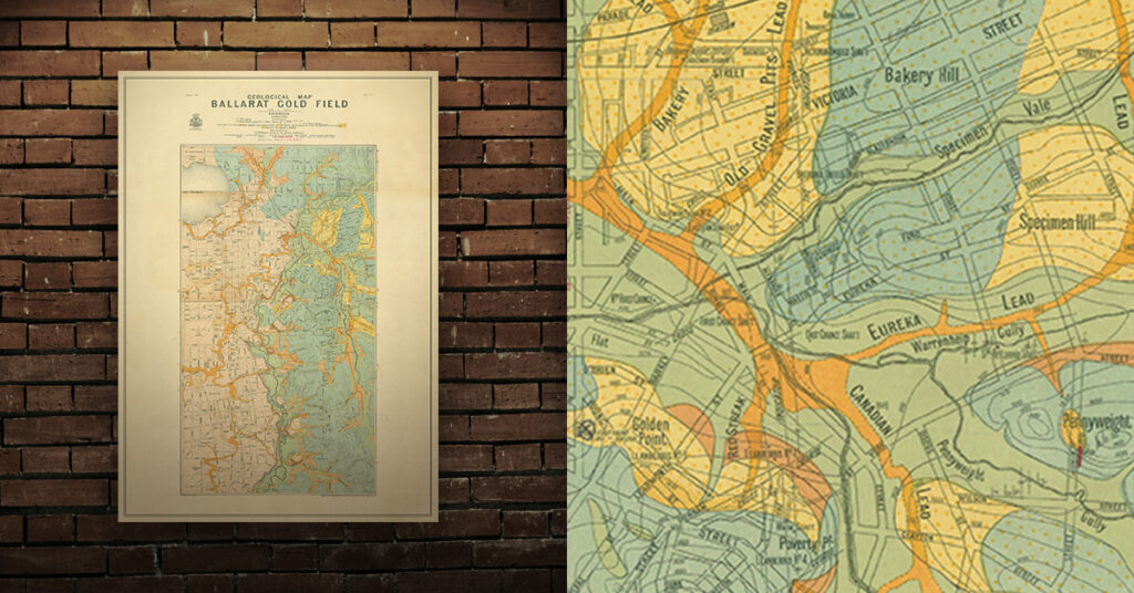
Shop now – High quality A1 print – Historical map of the Ballarat Goldfield