Directory of historical goldfields maps for Ararat, free to view online.
“Great rush at Mount Ararat – Intelligence has been received, in town of a great rush to these diggings consequent on the discovery of a lead of extraordinary richness. It is stated to be about two miles in length and seven claims wide, and the central claims are described as enormously rich. The quartz is struck at about 40 feet deep, and the washing stuff is yielding one pound of gold to the bucket. There were about 6000 persons there on Thursday, one half of whom are Chinese. The Chinese were daily arriving overland from Adelaide.” – The Age, 5th June 1857.
The rush to Ararat began in the 1850s, with multiple discoveries being made – first at Pinkey Point, then on the Canton Lead, and then Blackman’s Lead, which really set things off.
Chinese miners played a huge part in the establishment of Ararat, discovering its early riches on the Canton Lead.
These maps provide geological information of the Ararat goldfield along with detailed notes, and an excellent look at the Langi Logan lead system.
Ararat gold maps
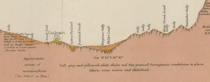
- 1875, Ararat gold field, Mining Department. Shows quartz reefs, dykes, dips, post pliocene, upper newer pliocene, lower newer pliocene, older pliocene, lower silurian, granite, upper volcanic. Includes notes. Second page shows detailed sections and particulars of bores.
- 1917, plan of portion of the Langi Logan lead system, near Ararat, Geological Survey of Victoria. Shows bedrock levels, private and government bores, recent, tertiary, devonian, and ordovician.